
Thank you for supporting this site ❤️
Make a donation
Make a donation
Schlettwein topographic map
Click on the map to display elevation.
Thank you for supporting this site ❤️
Make a donation
Make a donation
About this map
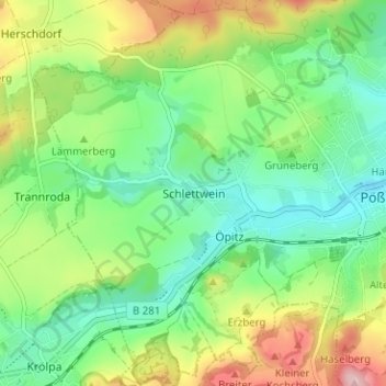
Name: Schlettwein topographic map, elevation, terrain.
Average elevation: 280 m
Minimum elevation: 215 m
Maximum elevation: 400 m
Thank you for supporting this site ❤️
Make a donation
Make a donation
Other topographic maps
Click on a map to view its topography, its elevation and its terrain.
Schweinitz
Deutschland > Thüringen > Saale-Orla-Kreis > Pößneck
Das von dem gleichnamigen Bach durchflossene Angerdorf Schweinitz liegt nordnordöstlich von Pößneck und östlich der im Orlatal verlaufenden Landesstraße 1108 von Pößneck nach Orlamünde. Im Orlatal verläuft auch die Bahnlinie Pößneck-Orlamünde. Der Ort liegt am Fuß der Anhöhe gen Langendembach zur…
Average elevation: 234 m