
Thank you for supporting this site ❤️
Make a donation
Make a donation
Yozgat topographic map
Click on the map to display elevation.
Thank you for supporting this site ❤️
Make a donation
Make a donation
Yozgat
The town is located at an elevation of 4,380 ft (1,335 m), situated 105 mi (170 km) east of Ankara, near the head of a narrow valley through which the Ankara–Sivas road runs. Like much of the Anatolian Plateau, the lands around Yozgat have been deforested over thousands of years of human habitation. This makes the climate and weather harsh, in summers and winters. However, Turkey has taken great steps to reforest at least some of the region.
Thank you for supporting this site ❤️
Make a donation
Make a donation
About this map
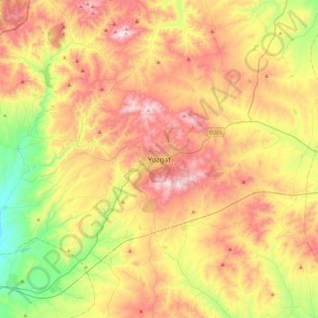
Name: Yozgat topographic map, elevation, terrain.
Average elevation: 1,250 m
Minimum elevation: 853 m
Maximum elevation: 1,689 m
Thank you for supporting this site ❤️
Make a donation
Make a donation