
Thank you for supporting this site ❤️
Make a donation
Make a donation
Charlotte topographic map
Click on the map to display elevation.
Thank you for supporting this site ❤️
Make a donation
Make a donation
About this map
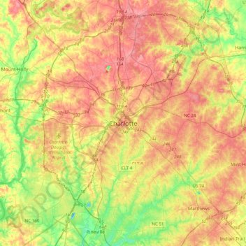
Name: Charlotte topographic map, elevation, terrain.
Average elevation: 211 m
Minimum elevation: 149 m
Maximum elevation: 271 m
Thank you for supporting this site ❤️
Make a donation
Make a donation
Other topographic maps
Click on a map to view its topography, its elevation and its terrain.
Coulwood Park
United States > North Carolina > Mecklenburg County > Charlotte > Coulwood Hills
Average elevation: 211 m
Idlewild Farms
United States > North Carolina > Mecklenburg County > Charlotte
Average elevation: 222 m
Thank you for supporting this site ❤️
Make a donation
Make a donation
Mecklenberg Wildlife Club Lake
United States > North Carolina > Mecklenburg County > Charlotte
Average elevation: 214 m
Beverly Woods East
United States > North Carolina > Mecklenburg County > Charlotte
Average elevation: 203 m
Carmel Road Park
United States > North Carolina > Mecklenburg County > Charlotte > Carmel Woods
Average elevation: 198 m
Thank you for supporting this site ❤️
Make a donation
Make a donation