
Thank you for supporting this site ❤️
Make a donation
Make a donation
Mustang topographic map
Click on the map to display elevation.
Thank you for supporting this site ❤️
Make a donation
Make a donation
Mustang
The district is a part of Gandaki Province in northern Nepal, straddles the Himalayas and extends northward onto the Tibetan Plateau. The district is one of the remotest areas in Nepal and is second in terms of the sparsity of population. The elevation ranges from 1,372 to 8,167 meters (Mount Dhaulagiri, the 7th highest mountain in the world), with several peaks above 7,000 meters.
Thank you for supporting this site ❤️
Make a donation
Make a donation
About this map
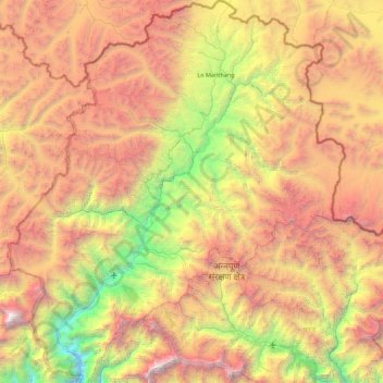
Name: Mustang topographic map, elevation, terrain.
Location: Mustang, Gandaki Province, 33100, Nepal (28.56450 83.47900 29.33125 84.25171)
Average elevation: 4,938 m
Minimum elevation: 2,335 m
Maximum elevation: 8,142 m
Thank you for supporting this site ❤️
Make a donation
Make a donation
Other topographic maps
Click on a map to view its topography, its elevation and its terrain.