
Make a donation
Ardèche topographic map
Click on the map to display elevation.
Make a donation
Ardèche
The department, corresponding to the ancient province of Vivarais, is part of the current region of Auvergne-Rhône-Alpes and is surrounded by the French departments of Drôme, Vaucluse, Gard, Lozère, Haute-Loire, Loire and Isère. It is a land of great contrasts: at the lowest it is at a mere 40 metres of elevation above sea level at the point at which the Ardèche river flows into the Rhône (in the southeast of the department) up to 1,754 metres at Mont Mézenc (centre-west), it is bordered to the east by the length of the Rhône valley for 140 km and to the west by the high plateaus of the Massif Central.
Make a donation
About this map
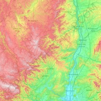
Name: Ardèche topographic map, elevation, terrain.
Location: Ardèche, Auvergne-Rhône-Alpes, Metropolitan France, France (44.26434 3.86110 45.36622 4.88624)
Average elevation: 639 m
Minimum elevation: 40 m
Maximum elevation: 1,702 m
Make a donation