
Make a donation
Roustika topographic map
Click on the map to display elevation.
Make a donation
Roustika
Roustika is located twenty kilometers southwest of Rethymno at an altitude of 290 m at the foot of the hill Ambelos. Roustika existed before the conquest of Crete by the Venetians. The name could originate from the Arabic word Roustak (which means: village) and it is believed that the Venetians adapted the name to their language as Roustika. Others believe it originates from the Latin word rustic (=rural).
Make a donation
About this map
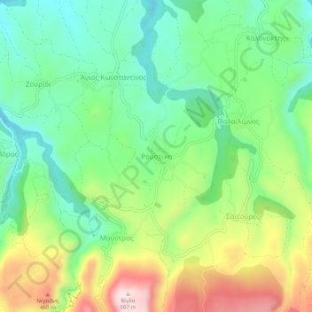
Name: Roustika topographic map, elevation, terrain.
Average elevation: 297 m
Minimum elevation: 147 m
Maximum elevation: 561 m
Make a donation
Other topographic maps
Click on a map to view its topography, its elevation and its terrain.
Municipality of Agios Vasileios
Greece > Region of Crete > Rethymno Regional Unit
Average elevation: 247 m
Myli Gorge
Greece > Region of Crete > Rethymno Regional Unit > Xiro Chorio > Myli
Average elevation: 198 m
Make a donation