
Thank you for supporting this site ❤️
Make a donation
Make a donation
Puerta Verde topographic map
Click on the map to display elevation.
Thank you for supporting this site ❤️
Make a donation
Make a donation
About this map
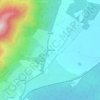
Name: Puerta Verde topographic map, elevation, terrain.
Average elevation: 1,002 m
Minimum elevation: 876 m
Maximum elevation: 1,537 m
Thank you for supporting this site ❤️
Make a donation
Make a donation
Other topographic maps
Click on a map to view its topography, its elevation and its terrain.
Arboreto Luis Ceballos
España > Comunidad de Madrid > San Lorenzo de El Escorial
Average elevation: 1,310 m