
Thank you for supporting this site ❤️
Make a donation
Make a donation
Westphalia topographic map
Click on the map to display elevation.
Thank you for supporting this site ❤️
Make a donation
Make a donation
About this map
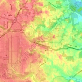
Name: Westphalia topographic map, elevation, terrain.
Location: Westphalia, Prince George's County, Maryland, United States (38.77989 -76.87372 38.85989 -76.79372)
Average elevation: 62 m
Minimum elevation: 10 m
Maximum elevation: 93 m
Thank you for supporting this site ❤️
Make a donation
Make a donation
Other topographic maps
Click on a map to view its topography, its elevation and its terrain.
Dinosaur Park
United States > Maryland > Prince George's County > South Laurel > Montpelier Forest
Average elevation: 67 m
Thank you for supporting this site ❤️
Make a donation
Make a donation
Thank you for supporting this site ❤️
Make a donation
Make a donation
Thank you for supporting this site ❤️
Make a donation
Make a donation
District Heights
United States > Maryland > Prince George's County > District Heights
Average elevation: 77 m
Thank you for supporting this site ❤️
Make a donation
Make a donation