
Make a donation
Zincirlikuyu topographic map
Click on the map to display elevation.
Make a donation
About this map
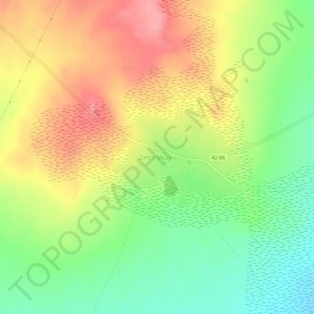
Name: Zincirlikuyu topographic map, elevation, terrain.
Location: Zincirlikuyu, Kulu, Konya, Central Anatolia Region, Turkey (38.90857 33.09016 38.94857 33.13016)
Average elevation: 963 m
Minimum elevation: 913 m
Maximum elevation: 1,015 m
Make a donation
Other topographic maps
Click on a map to view its topography, its elevation and its terrain.
Amasra
In the late 8th century its bishop obtained from the Byzantine Emperor its elevation to the rank of autocephalous archeparchy. It is listed as such in the Notitia Episcopatuum attributed to Basil the Armenian (c. 840) and in that of Leo VI the Wise (early 10th century).
Average elevation: 121 m
Make a donation
Make a donation
Make a donation
Köroğlu Mountains
Two ski resorts near Köroğlu Tepesi were inaugurated: Kartalkaya and Sarialan, with elevations between 1,900 m (6,233 ft) and 2,378 m (7,802 ft).
Average elevation: 854 m
Make a donation
Taurus Mountains
The mountains have a Mediterranean climate, with dry summers and rainy winters. Temperatures vary with elevation, with warm winters on the lower coastal slopes and cold winters in the high mountains and in the interior.
Average elevation: 828 m
Arhavi
Very rugged topography of the district and the supply structure is defective in a particular period and it says connecting Şahinkaya Poplar, agar, Fish, and Lome says Double Bridge and erode the land is deeply split. Therefore, roughly 2,000 feet (610 m) from the area between the flat coastal plain with no…
Average elevation: 1,029 m
Make a donation
Make a donation
Ayvacık
Ayvacık (Turkish: [ˈajvadʒɯk]) is a town in Çanakkale Province in the Marmara region of Turkey. It is the seat of Ayvacık District. Its population is 9,710 (2021). The town lies at an elevation of 252 m (827 ft). During the Gallipoli campaign in World War I, it was the target of several Allied attacks.
Average elevation: 168 m
Make a donation
Ezine
Ezine is a town in Çanakkale Province in the Marmara Region of Turkey. It is the seat of Ezine District. Its population is 15,408 (2021). The town lies at an elevation of 32 m (105 ft). Ezine is famous for its white cheese, made with cow, goat or sheep milk and called Ezine Peyniri.
Average elevation: 159 m
Make a donation
Make a donation
Ürgüp
Ürgüp (Greek: Προκόπιο Prokópio, Cappadocian Greek: Προκόπι Prokópi, Ottoman Turkish: Burgut Kalesi) is a town in Nevşehir province in the Cappadocia area of Central Anatolia, Turkey. It is the seat of Ürgüp District. Its population is 24,647 (2022). The town lies at an average elevation of 1,044 m (3,425 ft).
Average elevation: 1,161 m
Make a donation
Make a donation
Make a donation
Make a donation
Make a donation
Make a donation
Make a donation
Seferihisar
Seferihisar is a municipality and district of İzmir Province, Turkey. Its area is 375 km2, and its population is 60,914 (2024). Seferihisar district area borders on other İzmir districts of Urla to the west and Menderes to the east, and touches İzmir's westernmost metropolitan district of Güzelbahçe in…
Average elevation: 125 m
Gölcük Gölü
It is a lake hosted in a maar whose rim is 150 to 300 m high from the water surface. The lake is located at an altitude of 1380 m, has an area of 105 hectares, a width of 2.5 km, and a depth of 32 m. It is fed by springs at the bottom of the lake and by rainwater. The lake's water is fresh. For a while, the…
Average elevation: 1,442 m
Make a donation
Make a donation
Kaçkar Mountains
With the highest peak, Kaçkar Dağı, at an elevation of 3,937 metres (12,917 ft), and mountain plateaus at about 3,000 m (9,800 ft) in elevation, the range is the highest part of the Pontic Mountains. The Kaçkars are glaciated mountains that are alpine in character, with steep rocky peaks and numerous…
Average elevation: 887 m
Make a donation
Make a donation
Make a donation
Make a donation
Make a donation
Bergama
Kozak Plateau (Kozak Yaylası) is a high plain at an altitude varying between 500 and 1,000 metres (1,600 and 3,300 feet) and starting at a distance of 20 km (12 mi) from Bergama center in the northern direction. The plain is a favorite regional excursion area, famed for its hand-made textile products and pine…
Average elevation: 323 m
Make a donation
Make a donation