
Thank you for supporting this site ❤️
Make a donation
Make a donation
Methana topographic map
Click on the map to display elevation.
Thank you for supporting this site ❤️
Make a donation
Make a donation
Methana
Since 1991, the peninsula has been investigated by the team of ETH Zürich geologically and cartographically. From this, a topographical map of the entire peninsula at a scale of 1:25,000 was made. An interactive 3D map was created and is on the World Wide Web. Also a rich photographic archive with about 10.000 color slides has been produced (see links below).
Thank you for supporting this site ❤️
Make a donation
Make a donation
About this map
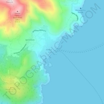
Name: Methana topographic map, elevation, terrain.
Average elevation: 123 m
Minimum elevation: -2 m
Maximum elevation: 667 m
Thank you for supporting this site ❤️
Make a donation
Make a donation