
Thank you for supporting this site ❤️
Make a donation
Make a donation
Decatur Island topographic map
Click on the map to display elevation.
Thank you for supporting this site ❤️
Make a donation
Make a donation
About this map
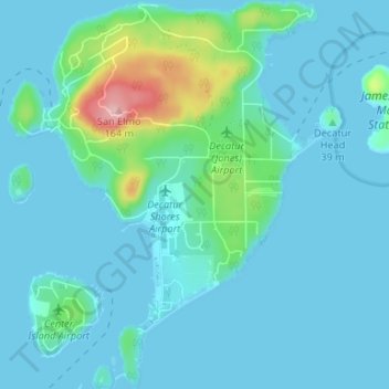
Name: Decatur Island topographic map, elevation, terrain.
Location: Decatur Island, San Juan County, Washington, United States (48.48105 -122.84004 48.52494 -122.78316)
Average elevation: 22 m
Minimum elevation: -2 m
Maximum elevation: 169 m
Thank you for supporting this site ❤️
Make a donation
Make a donation