
冷碛镇 topographic map
Interactive map
Click on the map to display elevation.
About this map
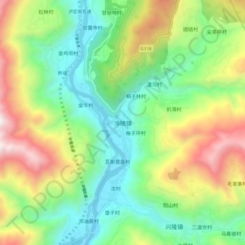
Name: 冷碛镇 topographic map, elevation, terrain.
Location: 冷碛镇, 泸定县, 甘孜藏族自治州, 四川省, 626100, 中国 (29.74896 102.18596 29.82896 102.26596)
Average elevation: 1,837 m
Minimum elevation: 1,223 m
Maximum elevation: 2,945 m
Other topographic maps
Click on a map to view its topography, its elevation and its terrain.