
Thank you for supporting this site ❤️
Make a donation
Make a donation
King topographic map
Click on the map to display elevation.
Thank you for supporting this site ❤️
Make a donation
Make a donation
About this map
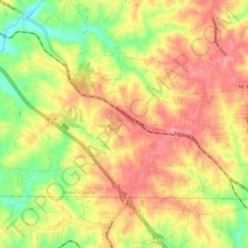
Name: King topographic map, elevation, terrain.
Location: King, Stokes County, North Carolina, United States (36.24611 -80.38730 36.31794 -80.32077)
Average elevation: 308 m
Minimum elevation: 253 m
Maximum elevation: 350 m
Thank you for supporting this site ❤️
Make a donation
Make a donation
Other topographic maps
Click on a map to view its topography, its elevation and its terrain.
Thank you for supporting this site ❤️
Make a donation
Make a donation
Thank you for supporting this site ❤️
Make a donation
Make a donation
Thank you for supporting this site ❤️
Make a donation
Make a donation