
Chlef topographic map
Interactive map
Click on the map to display elevation.
About this map
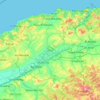
Name: Chlef topographic map, elevation, terrain.
Location: Chlef, Algeria (35.85122 0.69084 36.55563 1.72062)
Average elevation: 328 m
Minimum elevation: 0 m
Maximum elevation: 1,959 m
Other topographic maps
Click on a map to view its topography, its elevation and its terrain.
Tassili n'Ajjer
Tassili n'Ajjer lies within the West Saharan montane xeric woodlands ecoregion. Due to the higher elevation of the area, coupled with the water-retentive properties of the sandstone, the vegetation here is somewhat more lush and verdant than in the lower regions of desert; in turn, this creates an attractive…
Average elevation: 842 m
Bordj el Bahri Faizi
Algeria > Algiers > Dar el-Beida District > Bordj El Bahri
Average elevation: 19 m
Erg Chech
It is an almost uninhabited part of the greater Sahara Desert, an inhospitable desert region with long, extremely hot summers and short, very warm winters. The Erg Chech is a vast sandy expanse including compound and complex linear and star dunes. The mean elevation of the Erg Chech is just above 300 m,…
Average elevation: 335 m
Hoggar Mountains
Algeria > Tamanrasset > de Tamanrasset District > Tamanghasset
This mountainous region is located about 1,500 km (930 mi) south of the capital, Algiers. The area is largely rocky desert with an average elevation of more than 900 m (3,000 ft) above sea level. The highest peak, Mount Tahat, is at 2,908 m (9,541 ft). The mountains are primarily composed of metamorphic rock…
Average elevation: 2,451 m
The subdivision Mandariniers
Algeria > Algiers > Dar el-Beida District > Al Muhammadiyya > Pins Maritimes
Average elevation: 17 m
Algiers
Algeria > Algiers > Sidi M'Hamed District > Alger-Centre
Algiers was a walled city from the time of the deys until the close of the 19th century. The French, after their occupation of the city (1830), built a rampart, parapet and ditch, with two terminal forts, Bab Azoun باب عزون to the south and Bab-el-Oued اد to the north. The forts and part of the…
Average elevation: 45 m
Ouled Chebacheb
Algeria > Boumerdès > Khemis El Khechna District > Khemis El Khechna
Average elevation: 36 m
Algiers
Algeria > Algiers > Sidi M'Hamed District > Alger-Centre
Algiers was a walled city from the time of the deys until the close of the 19th century. The French, after their occupation of the city (1830), built a rampart, parapet and ditch, with two terminal forts, Bab Azoun باب عزون to the south and Bab-el-Oued اد to the north. The forts and part of the…
Average elevation: 45 m
Clos de car
Algeria > Algiers > Dar el-Beida District > Bordj El Bahri > Bordj el Bahri Faizi
Average elevation: 19 m
Algiers
Algeria > Algiers > Sidi M'Hamed District > Alger-Centre
Algiers was a walled city from the time of the deys until the close of the 19th century. The French, after their occupation of the city (1830), built a rampart, parapet and ditch, with two terminal forts, Bab Azoun باب عزون to the south and Bab-el-Oued اد to the north. The forts and part of the…
Average elevation: 45 m
Ihrir
Algeria > Djanet > Djanet District
Iherir is located at an elevation of 1,070 metres (3,510 ft) above sea level. Its valley is an oasis containing gueltas and numerous date palms. The town is notable for the dramatic rocky mountain ranges that rise as much as 300 metres (980 ft) on all sides. Prehistoric art dated to 9000 BC is found in the…
Average elevation: 1,218 m
Taza National Park
Algeria > Jijel > El Aouana District > Selma Ben Ziada
At lower altitudes, the Guerrouch forest is largely dominated by cork oaks, but higher up Algerian chestnut-leaved oak (Quercus afares) and Algerian oak (Quercus canariensis) are also present and there is a plentiful understorey of bird cherry (Prunus avium), Mediterranean willow (Salix pedicellata), European…
Average elevation: 437 m
Dhayat sidi belkacem
Algeria > Ghardaia > Dhaïa Ben Dhahoua District > Dhayet Bendhahoua
Average elevation: 630 m
Agouni Bouafir
Algeria > Tizi Ouzou > Mekla District > Mekla > Agouni Bouafir
Average elevation: 465 m
Azaghar (chamlal)
Algeria > Tizi Ouzou > Tizi Ouzou District > Tizi Ouzou > Ioualayen
Average elevation: 103 m