
Thank you for supporting this site ❤️
Make a donation
Make a donation
Lerones topographic map
Click on the map to display elevation.
Thank you for supporting this site ❤️
Make a donation
Make a donation
About this map
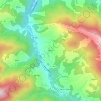
Name: Lerones topographic map, elevation, terrain.
Location: Lerones, Pesaguero, Cantabria, 39574, España (43.07700 -4.58085 43.11700 -4.54085)
Average elevation: 733 m
Minimum elevation: 399 m
Maximum elevation: 1,235 m
Thank you for supporting this site ❤️
Make a donation
Make a donation