
Thank you for supporting this site ❤️
Make a donation
Make a donation
Komolgonj topographic map
Click on the map to display elevation.
Thank you for supporting this site ❤️
Make a donation
Make a donation
About this map
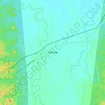
Name: Komolgonj topographic map, elevation, terrain.
Average elevation: 24 m
Minimum elevation: 16 m
Maximum elevation: 59 m
Thank you for supporting this site ❤️
Make a donation
Make a donation
Other topographic maps
Click on a map to view its topography, its elevation and its terrain.
Lawachara National Park
Bangladesh > Sylhet Division > Kamalganj Upazila > Doluchara
Average elevation: 47 m