
Thank you for supporting this site ❤️
Make a donation
Make a donation
Somtet topographic map
Click on the map to display elevation.
Thank you for supporting this site ❤️
Make a donation
Make a donation
About this map
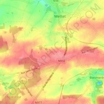
Name: Somtet topographic map, elevation, terrain.
Location: Somtet, Mettet, Namur, Wallonia, 5640, Belgium (50.28741 4.63365 50.32741 4.67365)
Average elevation: 252 m
Minimum elevation: 204 m
Maximum elevation: 280 m
Thank you for supporting this site ❤️
Make a donation
Make a donation
Other topographic maps
Click on a map to view its topography, its elevation and its terrain.