
Massachusetts topographic map
Click on the map to display elevation.
Massachusetts
Massachusetts features a diverse and varied topography. The western part of the state is dominated by the Berkshire Hills and Taconic Mountains, including Mount Greylock, the highest point at 3,491 feet (1,064 meters). The central region is marked by rolling hills, part of the broader New England Upland, which gradually slopes down to the Connecticut River Valley—a fertile, low-lying area ideal for agriculture. To the east, the terrain flattens as it reaches the Coastal Lowlands, a region characterized by sandy soils, wetlands, and a rugged, indented coastline that stretches along the Atlantic Ocean. This coastal area includes notable features like Cape Cod and the islands of Martha’s Vineyard and Nantucket.
About this map
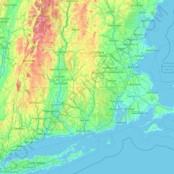
Name: Massachusetts topographic map, elevation, terrain.
Location: Massachusetts, United States (41.18886 -73.50821 42.88678 -69.86010)
Average elevation: 128 m
Minimum elevation: -7 m
Maximum elevation: 1,159 m
Other topographic maps
Click on a map to view its topography, its elevation and its terrain.
San Francisco Bay Area
United States > California > San Francisco
The San Francisco Bay Area is characterized by a diverse and dynamic topography shaped by geological processes over millions of years. This region features a combination of coastal plains, steep hills, and rugged mountains, all influenced by the tectonic activity associated with the nearby San Andreas Fault…
Average elevation: 113 m
Baltimore
United States > Maryland > Baltimore
Baltimore is in north-central Maryland on the Patapsco River close to where it empties into the Chesapeake Bay. The city is also located on the fall line between the Piedmont Plateau and the Atlantic coastal plain, which divides Baltimore into "lower city" and "upper city". The city's elevation ranges from sea…
Average elevation: 65 m
Scottsdale
United States > Arizona > Maricopa County > Scottsdale
The city is in the Salt River Valley, or the "Valley of the Sun," in the northern reaches of the Sonoran Desert. Scottsdale, 31 mi (50 km) long and 11.4 mi (18.3 km) wide at its widest point, shares boundaries with many other municipalities and entities. On the west, Scottsdale is bordered by Phoenix, Paradise…
Average elevation: 414 m
Appalachian Mountains
United States > North Carolina > Yancey County
The Appalachian Mountains (French: Appalaches), often called the Appalachians, are a system of mountains in eastern to northeastern North America. The Appalachians first formed roughly 480 million years ago during the Ordovician Period. They once reached elevations similar to those of the Alps and the Rocky…
Average elevation: 1,463 m
Palm Harbor
United States > Florida > Pinellas County
Palm Harbor is characterized by its unique topography, which features a relatively rare hilly landscape for the region. Unlike much of the surrounding areas in Pinellas County, which are predominantly flat, Palm Harbor includes elevations that can reach up to about 75 feet above sea level. This elevation gives…
Average elevation: 9 m
Columbus
United States > Ohio > Franklin County > Columbus
The confluence of the Scioto and Olentangy rivers is just north-west of Downtown Columbus. Several smaller tributaries course through the Columbus metropolitan area, including Alum Creek, Big Walnut Creek, and Darby Creek. Columbus is considered to have relatively flat topography thanks to a large glacier that…
Average elevation: 255 m
Virginia Beach
United States > Virginia > Virginia Beach
According to the United States Census Bureau, the city has a total area of 497 square miles (1,290 km2), of which 249 square miles (640 km2) is land and 248 square miles (640 km2) (49.9%) is water. It is the largest city in Virginia by total area and third-largest city land area. The average elevation is 12…
Average elevation: 2 m
Port Charlotte
United States > Florida > Charlotte County
Port Charlotte is characterized by a predominantly flat and low-lying terrain, typical of Florida’s coastal landscape. The area features a network of waterways, including the Peace River and Charlotte Harbor, which provide ample opportunities for recreational activities like boating and fishing. Elevations…
Average elevation: 4 m
Cajon Pass
United States > California > San Bernardino County
Cajon Pass (/kəˈhoʊn/; Spanish: Puerto del Cajón or Paso del Cajón) is a mountain pass between the San Bernardino Mountains to the east and the San Gabriel Mountains to the west in Southern California. Created by the movements of the San Andreas Fault, it has an elevation of 3,777 ft (1,151 m). Located in…
Average elevation: 1,169 m
Central Park
United States > New York > New York County > New York
In June 1856, Fernando Wood appointed a "consulting board" of seven people, headed by author Washington Irving, to inspire public confidence in the proposed development. Wood hired military engineer Egbert Ludovicus Viele as the park's chief engineer, tasking him with a topographical survey of the site. The…
Average elevation: 26 m
Parrish
United States > Florida > Manatee County
Parrish features a predominantly flat terrain with an average elevation of approximately 36 feet above sea level. The area's landscape is characterized by gently rolling hills and low-lying regions, making it typical of the Central Florida topography. Surrounding Parrish are numerous wetlands and drainage…
Average elevation: 12 m
Wesley Chapel
United States > Florida > Pasco County
According to the United States Census Bureau, the CDP has a total area of 6.1 square miles (16 km2), of which 6.1 square miles (16 km2) is land and 0.04 square miles (0.10 km2) (0.49%) is water. The elevation is about 100 feet (30 m), combined with an inland location, creates more temperature variation in the…
Average elevation: 19 m
Santa Cruz Mountains
United States > California > Santa Clara County
The Santa Cruz Mountains are a region of great biological diversity, encompassing cool, moist coastal ecosystems as well as warm, dry chaparral. Much of the area in the Santa Cruz mountains is considered temperate rainforest. In valleys and moist ocean-facing slopes some of the southernmost coast redwoods…
Average elevation: 230 m
Albuquerque
United States > New Mexico > Bernalillo County
Albuquerque is located in north-central New Mexico. To its east are the Sandia–Manzano Mountains. The Rio Grande flows north to south through its center, while the West Mesa and Petroglyph National Monument make up the western part of the city. Albuquerque has one of the highest elevations of any major city…
Average elevation: 1,671 m
Estes Park
United States > Colorado > Larimer County
Estes Park sits at an elevation of 7,522 feet (2,293 m) on the front range of the Rocky Mountains at the eastern entrance of the Rocky Mountain National Park. Its north, south and east extremities border the Roosevelt National Forest. Lumpy Ridge lies immediately north of Estes Park.
Average elevation: 2,543 m
Jenny Lake
United States > Wyoming > Teton County
Jenny Lake is a starting point for many day and overnight hiking trips. The 7.1-mile (11.4 km) Jenny Lake Trail loops around the lake and is considered to be relatively easy due to the small altitude gain of 700 feet (210 m). However, the altitude increases rapidly once Cascade Canyon is entered.
Average elevation: 2,109 m
Evergreen
United States > Colorado > Jefferson County
Evergreen sits at an elevation of 7,220 feet (2,200 m) in the Rocky Mountains, 19 miles west of Denver, Colorado. Its addresses are oriented according to the Street_system_of_Denver.
Average elevation: 2,309 m
Jacksonville
United States > Florida > Duval County > Jacksonville
Just south of Jacksonville and north of Saint Augustine is the boundary of where the Floridian Peninsula ends and Continental North America begins; Jacksonville is north of that line. While still in the North American Coastal plain, the topography begins to take on slight Piedmont characteristics. Like the…
Average elevation: 9 m
Tug Hill
United States > New York > Oswego County
The core Tug Hill region encompasses 150,000 acres (610 km2) of unbroken, generally second-growth, northern hardwood forest, and is drained by a vast network of streams. Important rivers and streams whose headwaters are located within the Tug Hill region include the Mohawk River, Deer River, Salmon River, Mad…
Average elevation: 109 m
Mauna Kea
United States > Hawaii > Hawaiʻi County
Mauna Kea (/ˌmaʊnə ˈkeɪə/; Hawaiian: [ˈmɐwnə ˈkɛjə]; abbreviation for Mauna a Wākea) is a dormant volcano on the island of Hawaiʻi. Its peak is 4,207.3 m (13,803 ft) above sea level, making it the highest point in the state of Hawaiʻi and second-highest peak of an island on Earth. The peak is…
Average elevation: 3,978 m
Uinta Mountains
The high Uintas were extensively glaciated during the last ice age, and most of the large stream valleys on both the north and south sides of the range held long valley glaciers. However, despite reaching to over 13,500 feet (4,110 m) in elevation, the climate today is sufficiently dry that no glaciers…
Average elevation: 2,363 m
Grand Lake
United States > Colorado > Grand County
Established in 1881, Grand Lake sits at an elevation of 8,369 feet (2,551 m) and derives its name from the lake on whose shores it is situated: Grand Lake, the largest natural body of water in Colorado. The town of Grand Lake was originally an outfitting and supply point for the mining settlements of Lulu…
Average elevation: 2,630 m
Clarks Village
United States > Connecticut > Southeastern Connecticut Planning Region > Stonington
Average elevation: 17 m
Coden
United States > Alabama > Mobile County
Coden is located at 30°22′59″N 88°14′18″W / 30.38306°N 88.23833°W / 30.38306; -88.23833 and has an elevation of 7 feet (2 m).
Average elevation: 3 m
Flint
United States > Texas > Smith County
Flint is an unincorporated community in southeastern Smith County, Texas, United States. It lies along FM 2493, south of the city of Tyler, the county seat of Smith County. Its elevation is 522 feet (159 m). Although Flint is unincorporated, it has a post office, with the ZIP code of 75762.
Average elevation: 146 m
Riverside
United States > Connecticut > Western Connecticut Planning Region > Greenwich > Old Greenwich
Average elevation: 13 m
Groveland
United States > California > Tuolumne County
Groveland is a census-designated place (CDP) in Tuolumne County, California. Groveland sits at an elevation of 3,136 feet (956 m). The 2020 United States census reported Groveland's population was 540.
Average elevation: 898 m
Alto
United States > New Mexico > Lincoln County
Alto is located at an elevation of 7,550 feet (2,300 m) in the Lincoln National Forest, five miles (8.0 km) north of the village of Ruidoso. Alto received its name from the Spanish word "high" because of its elevation.
Average elevation: 2,285 m
Laytonville
United States > California > Mendocino County > Laytonville
Laytonville is a census-designated place (CDP) in Mendocino County, California, United States. Laytonville, is located 20 miles (32 km) north-northwest of Willits, at an elevation of 1670 feet (509 m). The population was 1,227 at the 2010 census, down from 1,301 at the 2000 census.
Average elevation: 536 m
Avila Beach
United States > California > San Luis Obispo County
The beach is less than 0.5 miles (0.8 km) long and sheltered in San Luis Bay, which is formed by Point San Luis on the west and Fossil Point on the east. Avila Beach faces south and the 600 foot elevation of Point San Luis breaks the prevailing northwesterly winds. It is therefore usually warmer than the other…
Average elevation: 46 m
Great Basin
United States > Nevada > Eureka County
The Great Basin is the largest area of contiguous endorheic watersheds, those with no outlets, in North America. It spans nearly all of Nevada, much of Utah, and portions of California, Idaho, Oregon, Wyoming, and Baja California. It is noted for both its arid climate and the basin and range topography that…
Average elevation: 1,918 m
Twain Harte
United States > California > Tuolumne County
Twain Harte is situated in Tuolumne County along Highway 108 at an elevation of 3,640 feet (1,110 m).
Average elevation: 1,123 m
Rocky Mountains
United States > Wyoming > Teton County
Agriculture and forestry are major industries. Agriculture includes dryland and irrigated farming and livestock grazing. Livestock are frequently moved between high-elevation summer pastures and low-elevation winter pastures, a practice known as transhumance.
Average elevation: 2,292 m
Dorrington
United States > California > Calaveras County
According to the United States Census Bureau, the CDP has a total area of 3.7 square miles (9.6 km2), 99.86% of it land. The elevation is 4,800 feet ASL.
Average elevation: 1,464 m
Indiana Dunes State Park
United States > Indiana > Porter County > Chesterton
Average elevation: 186 m