
Thank you for supporting this site ❤️
Make a donation
Make a donation
King Cove topographic map
Click on the map to display elevation.
Thank you for supporting this site ❤️
Make a donation
Make a donation
About this map
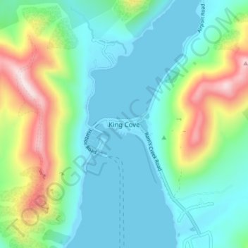
Name: King Cove topographic map, elevation, terrain.
Location: King Cove, Aleutians East, Alaska, 99612, United States (55.04096 -162.33841 55.08096 -162.29841)
Average elevation: 131 m
Minimum elevation: -3 m
Maximum elevation: 516 m
Thank you for supporting this site ❤️
Make a donation
Make a donation
Other topographic maps
Click on a map to view its topography, its elevation and its terrain.