
Thank you for supporting this site ❤️
Make a donation
Make a donation
Lowman topographic map
Click on the map to display elevation.
Thank you for supporting this site ❤️
Make a donation
Make a donation
About this map
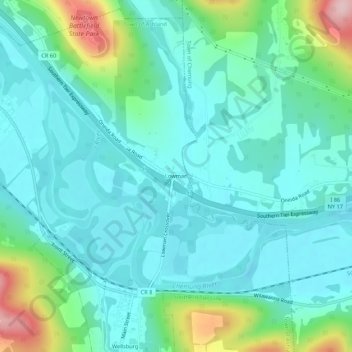
Name: Lowman topographic map, elevation, terrain.
Average elevation: 290 m
Minimum elevation: 238 m
Maximum elevation: 479 m
Thank you for supporting this site ❤️
Make a donation
Make a donation
Other topographic maps
Click on a map to view its topography, its elevation and its terrain.
Village of Elmira Heights
United States > New York > Chemung County > Town of Horseheads
Average elevation: 278 m
Thank you for supporting this site ❤️
Make a donation
Make a donation
Thank you for supporting this site ❤️
Make a donation
Make a donation
Village of Horseheads
United States > New York > Chemung County > Town of Horseheads
Average elevation: 298 m
Thank you for supporting this site ❤️
Make a donation
Make a donation