
Make a donation
Jinan topographic map
Click on the map to display elevation.
Make a donation
Jinan
Due to the mountains to the south of the city, temperature inversions are common, occurring on about 200 days per year. The high precipitation for northern Chinese standards, in tandem with the topography (mountains surrounding the city on three sides), leads to particularly oppressive summer weather and the city being named as a candidate for the fourth "furnace", c.e. Three Furnaces. Extremes since 1951 have ranged from −19.7 °C (−3 °F) on January 17, 1953, to 42.5 °C (109 °F) on July 24, 1955.
Make a donation
About this map
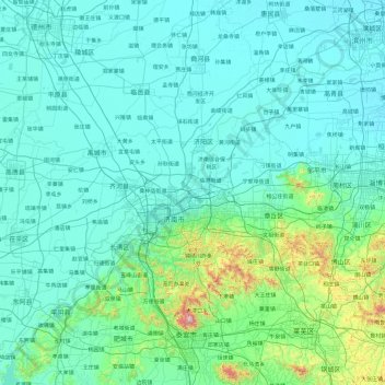
Name: Jinan topographic map, elevation, terrain.
Location: Jinan, Shandong, China (35.99207 116.21934 37.53691 117.97263)
Average elevation: 112 m
Minimum elevation: 6 m
Maximum elevation: 1,492 m
Make a donation
Other topographic maps
Click on a map to view its topography, its elevation and its terrain.
Make a donation
Make a donation
Qingdao
Qingdao is located on the south facing coast of the Shandong Peninsula (German: Schantung Halbinsel). It borders three prefecture-level cities, namely Yantai to the northeast, Weifang to the west, and Rizhao to the southwest. The city's total jurisdiction area occupies 10,654 square kilometres (4,114 sq mi),…
Average elevation: 25 m
Make a donation
Make a donation
Make a donation