
Make a donation
Oxie topographic map
Click on the map to display elevation.
Make a donation
Oxie
In the late 19th and early 20th century, the village expanded with the establishment of several brick and gravel industries. Remains from this era can still be seen in the topography of Oxie. Like in many other small, rural communities this rapid industrialisation was facilitated by the establishment of railroad communications.
Make a donation
About this map
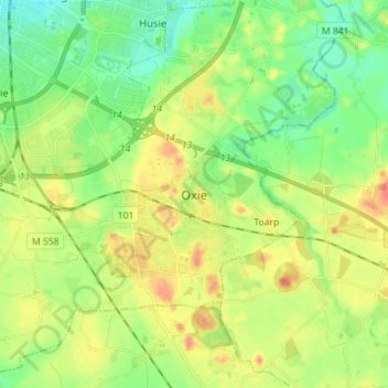
Name: Oxie topographic map, elevation, terrain.
Location: Oxie, Malmö kommun, Skåne County, 238 37, Sweden (55.50616 13.05679 55.58616 13.13679)
Average elevation: 34 m
Minimum elevation: 10 m
Maximum elevation: 69 m
Make a donation
Other topographic maps
Click on a map to view its topography, its elevation and its terrain.
Kullaberg
Sweden > Skåne County > Mölle
Kullaberg (Swedish pronunciation: [kɵlaˈbærj]) is a peninsula and nature reserve of land protruding into the Kattegat in Höganäs Municipality near the town of Mölle in southwest Sweden. The site in the province of Skåne is an area of considerable biodiversity supporting a number of rare species and has…
Average elevation: 22 m
Ven
Along the entire coast, the island drops steeply towards the sea where the Öresund meets a rocky beach. This steep coast is called Backafall. Ven's backafall is a nature reserve established in 1990. There are no large forests, but smaller stands of trees occur closest to the coast the slightly higher…
Average elevation: 13 m
Make a donation
Make a donation
Make a donation
Make a donation
Ven
Sweden > Skåne County > Tuna
Along the entire coast, the island drops steeply towards the sea where the Öresund meets a rocky beach. This steep coast is called Backafall. Ven's backafall is a nature reserve established in 1990. There are no large forests, but smaller stands of trees occur closest to the coast the slightly higher…
Average elevation: 13 m
Make a donation
Make a donation
Make a donation
Make a donation
Make a donation
Make a donation
Make a donation
Make a donation