
Thank you for supporting this site ❤️
Make a donation
Make a donation
Kendayakan topographic map
Click on the map to display elevation.
Thank you for supporting this site ❤️
Make a donation
Make a donation
About this map
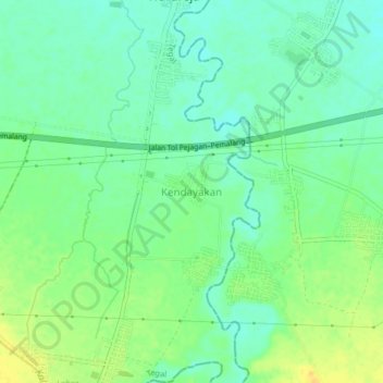
Name: Kendayakan topographic map, elevation, terrain.
Location: Kendayakan, Tegal, Central Java, Java, Indonesia (-6.96280 109.30718 -6.92280 109.34718)
Average elevation: 20 m
Minimum elevation: 9 m
Maximum elevation: 34 m
Thank you for supporting this site ❤️
Make a donation
Make a donation
Other topographic maps
Click on a map to view its topography, its elevation and its terrain.