
Thank you for supporting this site ❤️
Make a donation
Make a donation
Cedarville topographic map
Click on the map to display elevation.
Thank you for supporting this site ❤️
Make a donation
Make a donation
About this map
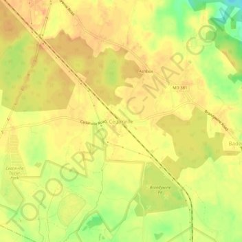
Name: Cedarville topographic map, elevation, terrain.
Location: Cedarville, Prince George's County, Maryland, United States (38.64290 -76.82219 38.68290 -76.78219)
Average elevation: 63 m
Minimum elevation: 36 m
Maximum elevation: 74 m
Thank you for supporting this site ❤️
Make a donation
Make a donation
Other topographic maps
Click on a map to view its topography, its elevation and its terrain.
Dinosaur Park
United States > Maryland > Prince George's County > South Laurel > Montpelier Forest
Average elevation: 67 m
Thank you for supporting this site ❤️
Make a donation
Make a donation
Thank you for supporting this site ❤️
Make a donation
Make a donation
Thank you for supporting this site ❤️
Make a donation
Make a donation
District Heights
United States > Maryland > Prince George's County > District Heights
Average elevation: 77 m
Thank you for supporting this site ❤️
Make a donation
Make a donation