
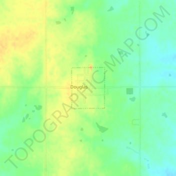
Douglas topographic map
Interactive map
Click on the map to display elevation.
About this map
Name: Douglas topographic map, elevation, terrain.
Location: Douglas, Garfield County, Oklahoma, United States (36.25723 -97.67067 36.26357 -97.66433)
Average elevation: 343 m
Minimum elevation: 329 m
Maximum elevation: 355 m
Other topographic maps
Click on a map to view its topography, its elevation and its terrain.
Carrier
United States > Oklahoma > Garfield County
Carrier, Garfield County, Oklahoma, 73727, United States
Average elevation: 414 m
Drummond
United States > Oklahoma > Garfield County
Drummond, Garfield County, Oklahoma, 73735, United States
Average elevation: 371 m
Garber
United States > Oklahoma > Garfield County
Garber, Garfield County, Oklahoma, 73738, United States
Average elevation: 354 m
Hunter
United States > Oklahoma > Garfield County
Hunter, Garfield County, Oklahoma, 74640, United States
Average elevation: 334 m
Kremlin
United States > Oklahoma > Garfield County
Kremlin, Garfield County, Oklahoma, 73753, United States
Average elevation: 341 m
Waukomis
United States > Oklahoma > Garfield County
Waukomis, Garfield County, Oklahoma, 73773, United States
Average elevation: 372 m
Lahoma
United States > Oklahoma > Garfield County
Lahoma, Garfield County, Oklahoma, United States
Average elevation: 383 m
Covington
United States > Oklahoma > Garfield County
Covington, Garfield County, Oklahoma, 73730, United States
Average elevation: 352 m
Fairmont
United States > Oklahoma > Garfield County
Fairmont, Garfield County, Oklahoma, 73736, United States
Average elevation: 364 m
Hillsdale
United States > Oklahoma > Garfield County > Hillsdale
Hillsdale, Garfield County, Oklahoma, 73743, United States
Average elevation: 375 m
North Enid
United States > Oklahoma > Garfield County
North Enid, Garfield County, Oklahoma, United States
Average elevation: 388 m
Enid
United States > Oklahoma > Garfield County
Enid, Garfield County, Oklahoma, United States
Average elevation: 380 m
Bison
United States > Oklahoma > Garfield County
Bison, Garfield County, Oklahoma, 73720, United States
Average elevation: 369 m
Breckinridge
United States > Oklahoma > Garfield County > Breckenridge
Breckinridge, Breckenridge, Garfield County, Oklahoma, United States
Average elevation: 365 m
Enid
United States > Oklahoma > Garfield County > Enid
Enid, Garfield County, Oklahoma, K, United States
Average elevation: 371 m