
Thank you for supporting this site ❤️
Make a donation
Make a donation
Richardson Springs topographic map
Click on the map to display elevation.
Thank you for supporting this site ❤️
Make a donation
Make a donation
Richardson Springs
Richardson Springs (formerly, Mud Springs) is an unincorporated community in Butte County, California. It is located on Mud Creek 8.5 miles (13.7 km) north-northeast of Chico, at an elevation of 620 feet (189 m). The place is named for J.H. and Lee Richardson, who founded mineral spas here in 1898. A post office was opened in 1933.
Thank you for supporting this site ❤️
Make a donation
Make a donation
About this map
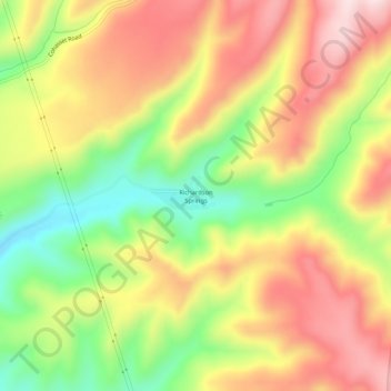
Name: Richardson Springs topographic map, elevation, terrain.
Average elevation: 335 m
Minimum elevation: 142 m
Maximum elevation: 509 m
Thank you for supporting this site ❤️
Make a donation
Make a donation
Other topographic maps
Click on a map to view its topography, its elevation and its terrain.
Thank you for supporting this site ❤️
Make a donation
Make a donation
Thank you for supporting this site ❤️
Make a donation
Make a donation