
Thank you for supporting this site ❤️
Make a donation
Make a donation
Highland State Recreation Area topographic map
Click on the map to display elevation.
Thank you for supporting this site ❤️
Make a donation
Make a donation
Highland State Recreation Area
West of Duck Lake Road in Highland State Recreation Area, a group of small moraines are locally called "mountains"—the highest elevation in the park, Mount Kanzer, is 1,150 feet (350 m) above sea level. The highland for which this recreation area is named is this group of moraines.
Thank you for supporting this site ❤️
Make a donation
Make a donation
About this map
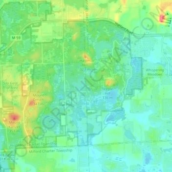
Name: Highland State Recreation Area topographic map, elevation, terrain.
Average elevation: 302 m
Minimum elevation: 282 m
Maximum elevation: 355 m
Thank you for supporting this site ❤️
Make a donation
Make a donation