
Thank you for supporting this site ❤️
Make a donation
Make a donation
Black Forest topographic map
Click on the map to display elevation.
Thank you for supporting this site ❤️
Make a donation
Make a donation
Black Forest
Its highest peak is the Feldberg with an elevation of 1,493 metres (4,898 ft) above sea level. Roughly oblong in shape, with a length of 160 kilometres (100 miles) and breadth of up to 50 km (30 mi),[2] it has an area of about 6,009 km2 (2,320 sq mi).[1]
Thank you for supporting this site ❤️
Make a donation
Make a donation
About this map
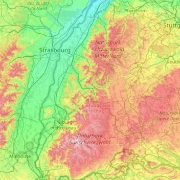
Name: Black Forest topographic map, elevation, terrain.
Location: Black Forest, Baden-Württemberg, Germany (47.55950 7.66408 48.98056 8.81081)
Average elevation: 469 m
Minimum elevation: 107 m
Maximum elevation: 1,471 m
Thank you for supporting this site ❤️
Make a donation
Make a donation