
Make a donation
Durango topographic map
Click on the map to display elevation.
Make a donation
Durango
Durango (Spanish pronunciation: [duˈɾaŋɡo], Southeastern Tepehuan: Korian) is the capital and largest city of the northern Mexican state of Durango and the seat of the municipality of Durango. It has a population of 616,068 as of the 2020 census with 688,697 living in the municipality. The city's official name is Victoria de Durango, renamed in honor of the first president of Mexico, Guadalupe Victoria, a native of the state of Durango. The city is at an altitude of 1,890 m (6,201 ft) in the Valley of Guadiana.
Make a donation
About this map
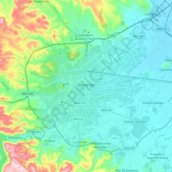
Name: Durango topographic map, elevation, terrain.
Location: Durango, Municipio de Durango, Durango, Mexico (23.94563 -104.73078 24.09514 -104.51793)
Average elevation: 1,936 m
Minimum elevation: 1,860 m
Maximum elevation: 2,225 m
Make a donation
Other topographic maps
Click on a map to view its topography, its elevation and its terrain.