
Thank you for supporting this site ❤️
Make a donation
Make a donation
Merazhofen topographic map
Click on the map to display elevation.
Thank you for supporting this site ❤️
Make a donation
Make a donation
About this map
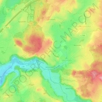
Name: Merazhofen topographic map, elevation, terrain.
Average elevation: 673 m
Minimum elevation: 616 m
Maximum elevation: 733 m
Thank you for supporting this site ❤️
Make a donation
Make a donation
Other topographic maps
Click on a map to view its topography, its elevation and its terrain.
Herlazhofen
Deutschland > Baden-Württemberg > Landkreis Ravensburg > Leutkirch im Allgäu
Average elevation: 690 m
Friesenhofen
Deutschland > Baden-Württemberg > Landkreis Ravensburg > Leutkirch im Allgäu
Average elevation: 743 m