
Thank you for supporting this site ❤️
Make a donation
Make a donation
Paravur topographic map
Click on the map to display elevation.
Thank you for supporting this site ❤️
Make a donation
Make a donation
Paravur
Paravur is located at 8.78 N 76 E. It has an average elevation of 10 metres (32 feet). Paravur, 21 kilometers from the Kollam, is a narrow skirt of land stretching in between the backwaters and the sea. There is an elevation of 6 metres above sea level, extending to 16 metres on the inland. Ithikkara river is flowing through paravur. Nedungolam in paravur is now famous for mangrove forest.
Thank you for supporting this site ❤️
Make a donation
Make a donation
About this map
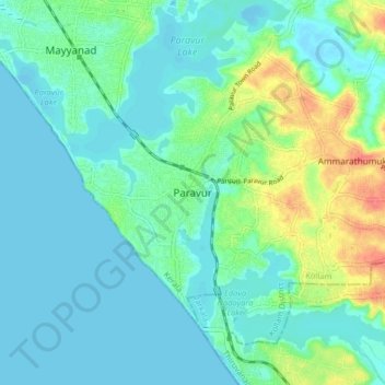
Name: Paravur topographic map, elevation, terrain.
Location: Paravur, Kollam, Kollam District, Kerala, 691301, India (8.76989 76.63153 8.84989 76.71153)
Average elevation: 14 m
Minimum elevation: -5 m
Maximum elevation: 60 m
Thank you for supporting this site ❤️
Make a donation
Make a donation
Other topographic maps
Click on a map to view its topography, its elevation and its terrain.