
Thank you for supporting this site ❤️
Make a donation
Make a donation
Mount Pink topographic map
Click on the map to display elevation.
Thank you for supporting this site ❤️
Make a donation
Make a donation
About this map
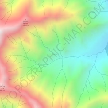
Name: Mount Pink topographic map, elevation, terrain.
Location: Mount Pink, Zambales, Central Luzon, Philippines (14.88606 120.12439 14.88616 120.12449)
Average elevation: 502 m
Minimum elevation: 91 m
Maximum elevation: 972 m
Thank you for supporting this site ❤️
Make a donation
Make a donation
Other topographic maps
Click on a map to view its topography, its elevation and its terrain.