
Thank you for supporting this site ❤️
Make a donation
Make a donation
Glen Carbon topographic map
Click on the map to display elevation.
Thank you for supporting this site ❤️
Make a donation
Make a donation
About this map
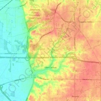
Name: Glen Carbon topographic map, elevation, terrain.
Location: Glen Carbon, Madison County, Illinois, United States (38.73700 -90.03883 38.78857 -89.92737)
Average elevation: 158 m
Minimum elevation: 123 m
Maximum elevation: 186 m
Thank you for supporting this site ❤️
Make a donation
Make a donation
Other topographic maps
Click on a map to view its topography, its elevation and its terrain.