
Thank you for supporting this site ❤️
Make a donation
Make a donation
Prince Edward Island topographic map
Click on the map to display elevation.
Thank you for supporting this site ❤️
Make a donation
Make a donation
About this map
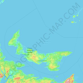
Name: Prince Edward Island topographic map, elevation, terrain.
Location: Prince Edward Island, Canada (45.84946 -64.55191 47.60248 -61.39937)
Average elevation: 8 m
Minimum elevation: -3 m
Maximum elevation: 314 m
Thank you for supporting this site ❤️
Make a donation
Make a donation
Other topographic maps
Click on a map to view its topography, its elevation and its terrain.
Gillis Lake
Canada > British Columbia > Thompson-Nicola Regional District > Area N (Beautiful Nicola Valley - South)
Average elevation: 1,210 m
Muskwa Ranges
Canada > British Columbia > Peace River Regional District > Area B (Finlay Valley/Beatton Valley)
Average elevation: 1,398 m
Thank you for supporting this site ❤️
Make a donation
Make a donation
Malakwa
Canada > British Columbia > Columbia-Shuswap Regional District > Area E (Eagle River Valley) > Malakwa
Average elevation: 470 m