
Thank you for supporting this site ❤️
Make a donation
Make a donation
Mira-sol topographic map
Click on the map to display elevation.
Thank you for supporting this site ❤️
Make a donation
Make a donation
About this map
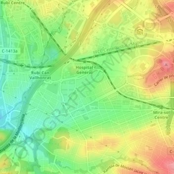
Name: Mira-sol topographic map, elevation, terrain.
Average elevation: 127 m
Minimum elevation: 83 m
Maximum elevation: 179 m
Thank you for supporting this site ❤️
Make a donation
Make a donation
Other topographic maps
Click on a map to view its topography, its elevation and its terrain.
Parque natural de Collserola
España > Cataluña > Vallés Occidental > Sant Cugat del Vallès
Average elevation: 131 m