
Thank you for supporting this site ❤️
Make a donation
Make a donation
Gräfenberg topographic map
Click on the map to display elevation.
Thank you for supporting this site ❤️
Make a donation
Make a donation
Gräfenberg
Gräfenberg is located in the southern part of Little Switzerland. The town is characterised by a great range of elevation (from 400 to 550 metres). A brook, the Kalkach, flows through the town with a steep drop.
Thank you for supporting this site ❤️
Make a donation
Make a donation
About this map
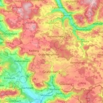
Name: Gräfenberg topographic map, elevation, terrain.
Average elevation: 468 m
Minimum elevation: 330 m
Maximum elevation: 579 m
Thank you for supporting this site ❤️
Make a donation
Make a donation
Other topographic maps
Click on a map to view its topography, its elevation and its terrain.
Thank you for supporting this site ❤️
Make a donation
Make a donation
Ebermannstadt
Germany > Bavaria > Landkreis Forchheim > Ebermannstadt > Ebermannstadt
Average elevation: 408 m