
Thank you for supporting this site ❤️
Make a donation
Make a donation
Mount Baker topographic map
Click on the map to display elevation.
Thank you for supporting this site ❤️
Make a donation
Make a donation
About this map
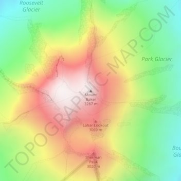
Name: Mount Baker topographic map, elevation, terrain.
Location: Mount Baker, Whatcom County, Washington, United States (48.77672 -121.81462 48.77682 -121.81452)
Average elevation: 2,699 m
Minimum elevation: 2,182 m
Maximum elevation: 3,274 m
Thank you for supporting this site ❤️
Make a donation
Make a donation
Other topographic maps
Click on a map to view its topography, its elevation and its terrain.
Bellingham
United States > Washington > Whatcom County
According to the United States Census Bureau, the city has a total area of 30.511 square miles (79.02 km2), of which, 28.198 square miles (73.03 km2) is land and 2.313 square miles (5.99 km2) is water. The lowest elevations are at sea level along the waterfront. Alabama Hill is one of the higher points in the…
Average elevation: 89 m