
Thank you for supporting this site ❤️
Make a donation
Make a donation
Jefferson topographic map
Click on the map to display elevation.
Thank you for supporting this site ❤️
Make a donation
Make a donation
Jefferson
Due to its high elevation, Jefferson has an oceanic or subtropical highland climate, (Köppen Cfb), with the coldst month of January averaging slightly above freezing, while summers are much milder than most of the southeast, with July averaging below 70 degrees fahrenheit.
Thank you for supporting this site ❤️
Make a donation
Make a donation
About this map
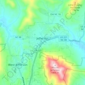
Name: Jefferson topographic map, elevation, terrain.
Location: Jefferson, Ashe County, North Carolina, United States (36.40475 -81.48950 36.43058 -81.42268)
Average elevation: 979 m
Minimum elevation: 841 m
Maximum elevation: 1,397 m
Thank you for supporting this site ❤️
Make a donation
Make a donation
Other topographic maps
Click on a map to view its topography, its elevation and its terrain.
Thank you for supporting this site ❤️
Make a donation
Make a donation
Thank you for supporting this site ❤️
Make a donation
Make a donation
Thank you for supporting this site ❤️
Make a donation
Make a donation
Thank you for supporting this site ❤️
Make a donation
Make a donation
Thank you for supporting this site ❤️
Make a donation
Make a donation