
Make a donation
Morgan County topographic map
Click on the map to display elevation.
Make a donation
Morgan County
Morgan County is where the glaciers stopped their southward advance during the last ice age. As a result, the area has both flat areas and rolling hills, with the most diverse soil of any county in the United States. The extensive woodlands of the eighteenth century have been cleared on the county's flat areas, with agricultural or urban uses dominating. The county is significantly carved with wooded drainages, leading to the southwest-flowing White River. According to radar telemetry gathered by the US Shuttle Radar Topographic Mission, Morgan County terrain ranges from 604 to 1,010 feet (184 to 308 meters) ASL.
Make a donation
About this map
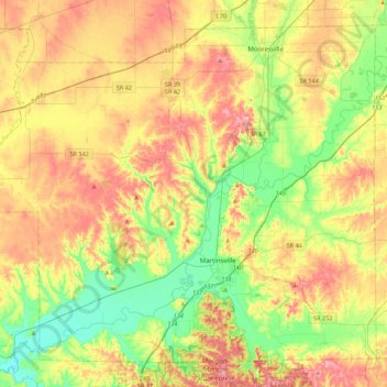
Name: Morgan County topographic map, elevation, terrain.
Location: Morgan County, Indiana, United States (39.33829 -86.68759 39.63365 -86.24897)
Average elevation: 224 m
Minimum elevation: 165 m
Maximum elevation: 295 m
Make a donation
Other topographic maps
Click on a map to view its topography, its elevation and its terrain.
Make a donation
Make a donation
Lake Station
United States > Indiana > Lake County > Lake Station > Lake Station
Average elevation: 189 m