
Thank you for supporting this site ❤️
Make a donation
Make a donation
Round Hill topographic map
Click on the map to display elevation.
Thank you for supporting this site ❤️
Make a donation
Make a donation
About this map
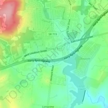
Name: Round Hill topographic map, elevation, terrain.
Location: Round Hill, Loudoun County, Virginia, 20141, United States (39.12350 -77.78995 39.13913 -77.76101)
Average elevation: 177 m
Minimum elevation: 130 m
Maximum elevation: 265 m
Thank you for supporting this site ❤️
Make a donation
Make a donation
Other topographic maps
Click on a map to view its topography, its elevation and its terrain.
Loudoun Valley Estates
United States > Virginia > Loudoun County
The land around Loudoun Valley Estates is gently rolling. The average elevation is 289 feet (88 m). The population density is about 500 people per square kilometer.
Average elevation: 91 m
Thank you for supporting this site ❤️
Make a donation
Make a donation
Thank you for supporting this site ❤️
Make a donation
Make a donation
Thank you for supporting this site ❤️
Make a donation
Make a donation