
Thank you for supporting this site ❤️
Make a donation
Make a donation
Logan topographic map
Click on the map to display elevation.
Thank you for supporting this site ❤️
Make a donation
Make a donation
About this map
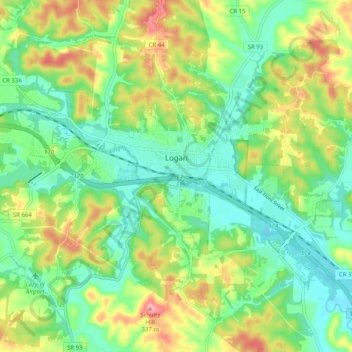
Name: Logan topographic map, elevation, terrain.
Location: Logan, Hocking County, Ohio, 43138, United States (39.51046 -82.46156 39.56086 -82.36054)
Average elevation: 254 m
Minimum elevation: 208 m
Maximum elevation: 336 m
Thank you for supporting this site ❤️
Make a donation
Make a donation
Other topographic maps
Click on a map to view its topography, its elevation and its terrain.
Thank you for supporting this site ❤️
Make a donation
Make a donation
Thank you for supporting this site ❤️
Make a donation
Make a donation
Thank you for supporting this site ❤️
Make a donation
Make a donation
Thank you for supporting this site ❤️
Make a donation
Make a donation
Thank you for supporting this site ❤️
Make a donation
Make a donation
Hocking Hills State Park Mountain Bike Trail Head
United States > Ohio > Hocking County
Average elevation: 306 m