
Thank you for supporting this site ❤️
Make a donation
Make a donation
Argentine topographic map
Click on the map to display elevation.
Thank you for supporting this site ❤️
Make a donation
Make a donation
About this map
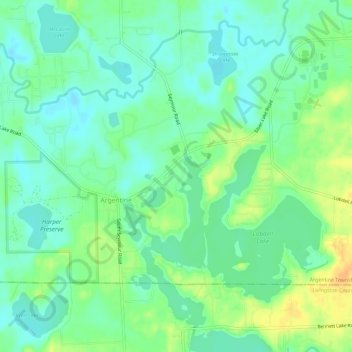
Name: Argentine topographic map, elevation, terrain.
Location: Argentine, Genesee County, Michigan, United States (42.78114 -83.86328 42.80740 -83.80542)
Average elevation: 265 m
Minimum elevation: 252 m
Maximum elevation: 286 m
Thank you for supporting this site ❤️
Make a donation
Make a donation
Other topographic maps
Click on a map to view its topography, its elevation and its terrain.
Genessee County Recreational Area
United States > Michigan > Genesee County > Genesee Charter Township
Average elevation: 231 m