
Thank you for supporting this site ❤️
Make a donation
Make a donation
Hog Lake topographic map
Click on the map to display elevation.
Thank you for supporting this site ❤️
Make a donation
Make a donation
About this map
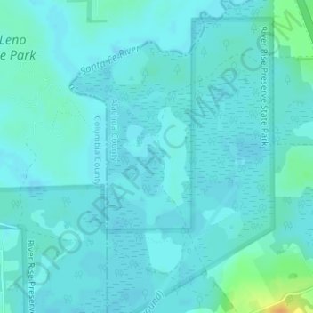
Name: Hog Lake topographic map, elevation, terrain.
Location: Hog Lake, Alachua County, Florida, United States (29.90815 -82.57123 29.90865 -82.57073)
Average elevation: 17 m
Minimum elevation: 12 m
Maximum elevation: 43 m
Thank you for supporting this site ❤️
Make a donation
Make a donation
Other topographic maps
Click on a map to view its topography, its elevation and its terrain.