
Thank you for supporting this site ❤️
Make a donation
Make a donation
Roundhead topographic map
Click on the map to display elevation.
Thank you for supporting this site ❤️
Make a donation
Make a donation
Roundhead
Located at an altitude of 1,004 feet (306 m), it sits at the intersection of State Routes 117, 235, and 385, 2.75 miles (4.43 km) north of the northeast corner of Indian Lake and 13 miles (21 km) southwest of the city of Kenton, the county seat of Hardin County. Despite Roundhead's proximity to Indian Lake and the Great Miami River, which flows out of it to the Ohio River at Cincinnati, the community is drained by the headwaters of the Scioto River, which meets the Ohio River at Portsmouth.
Thank you for supporting this site ❤️
Make a donation
Make a donation
About this map
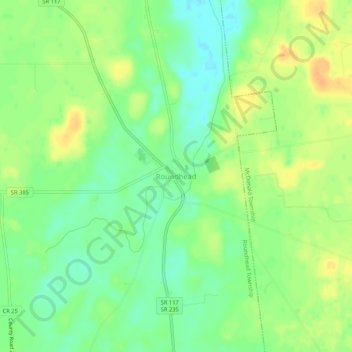
Name: Roundhead topographic map, elevation, terrain.
Average elevation: 311 m
Minimum elevation: 295 m
Maximum elevation: 327 m
Thank you for supporting this site ❤️
Make a donation
Make a donation
Other topographic maps
Click on a map to view its topography, its elevation and its terrain.
Thank you for supporting this site ❤️
Make a donation
Make a donation
Thank you for supporting this site ❤️
Make a donation
Make a donation