
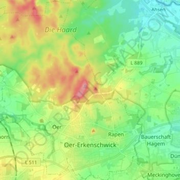
Oer-Erkenschwick topographic map
Interactive map
Click on the map to display elevation.
About this map
Name: Oer-Erkenschwick topographic map, elevation, terrain.
Average elevation: 80 m
Minimum elevation: 39 m
Maximum elevation: 154 m
Other topographic maps
Click on a map to view its topography, its elevation and its terrain.
Polsum
Duitsland > Noordrijn-Westfalen > Kreis Recklinghausen > Marl
Polsum, Marl, Kreis Recklinghausen, Noordrijn-Westfalen, 45896, Duitsland
Average elevation: 56 m
Holtwick
Duitsland > Noordrijn-Westfalen > Kreis Recklinghausen > Haltern am See > Holtwick
Holtwick, Haltern am See, Kreis Recklinghausen, Noordrijn-Westfalen, Duitsland
Average elevation: 71 m
Haltern am See
Duitsland > Noordrijn-Westfalen > Kreis Recklinghausen
Haltern am See, Kreis Recklinghausen, Noordrijn-Westfalen, 45721, Duitsland
Average elevation: 63 m
Lembeck
Duitsland > Noordrijn-Westfalen > Kreis Recklinghausen > Dorsten
Lembeck, Dorsten, Kreis Recklinghausen, Noordrijn-Westfalen, 46286, Duitsland
Average elevation: 67 m
Dorsten
Duitsland > Noordrijn-Westfalen > Kreis Recklinghausen
Dorsten, Kreis Recklinghausen, Noordrijn-Westfalen, Duitsland
Average elevation: 54 m
Gladbeck
Duitsland > Noordrijn-Westfalen > Kreis Recklinghausen
Gladbeck, Kreis Recklinghausen, Noordrijn-Westfalen, Duitsland
Average elevation: 55 m
Herten
Duitsland > Noordrijn-Westfalen > Kreis Recklinghausen
Herten, Kreis Recklinghausen, Noordrijn-Westfalen, Duitsland
Average elevation: 67 m