
Thank you for supporting this site ❤️
Make a donation
Make a donation
A Bandeira topographic map
Click on the map to display elevation.
Thank you for supporting this site ❤️
Make a donation
Make a donation
About this map
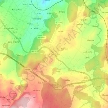
Name: A Bandeira topographic map, elevation, terrain.
Location: A Bandeira, Silleda, Deza, Pontevedra, Galicia, 36570, España (42.70894 -8.32290 42.74894 -8.28290)
Average elevation: 336 m
Minimum elevation: 218 m
Maximum elevation: 440 m
Thank you for supporting this site ❤️
Make a donation
Make a donation
Other topographic maps
Click on a map to view its topography, its elevation and its terrain.