
Thank you for supporting this site ❤️
Make a donation
Make a donation
Ishiara topographic map
Click on the map to display elevation.
Thank you for supporting this site ❤️
Make a donation
Make a donation
About this map
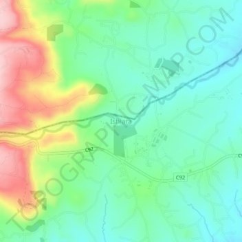
Name: Ishiara topographic map, elevation, terrain.
Location: Ishiara, Embu, East Kenya, Kenya (-0.47000 37.76330 -0.43000 37.80330)
Average elevation: 874 m
Minimum elevation: 803 m
Maximum elevation: 1,021 m
Thank you for supporting this site ❤️
Make a donation
Make a donation
Other topographic maps
Click on a map to view its topography, its elevation and its terrain.
Embu
The Municipality of Embu has an elevation of 1,350 metres (4,429 ft), and is located on the foothills of Mount Kenya. It was the provincial headquarters of the defunct Eastern province, and is currently the Embu County Headquarters, hosting major public offices and institutions, including Embu Provincial…
Average elevation: 1,352 m