
Thank you for supporting this site ❤️
Make a donation
Make a donation
Broadstairs topographic map
Click on the map to display elevation.
Thank you for supporting this site ❤️
Make a donation
Make a donation
About this map
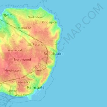
Name: Broadstairs topographic map, elevation, terrain.
Location: Broadstairs, Thanet, Kent, England, CT10 1LH, United Kingdom (51.31868 1.40079 51.39868 1.48079)
Average elevation: 14 m
Minimum elevation: 0 m
Maximum elevation: 56 m
Thank you for supporting this site ❤️
Make a donation
Make a donation
Other topographic maps
Click on a map to view its topography, its elevation and its terrain.