
Thank you for supporting this site ❤️
Make a donation
Make a donation
Green Mountain topographic map
Click on the map to display elevation.
Thank you for supporting this site ❤️
Make a donation
Make a donation
About this map
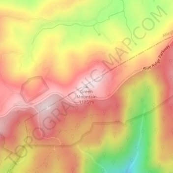
Name: Green Mountain topographic map, elevation, terrain.
Location: Green Mountain, Wilkes County, North Carolina, United States (36.43119 -81.11652 36.43129 -81.11642)
Average elevation: 997 m
Minimum elevation: 716 m
Maximum elevation: 1,170 m
Thank you for supporting this site ❤️
Make a donation
Make a donation
Other topographic maps
Click on a map to view its topography, its elevation and its terrain.
Rendezvous Mountain State Park
United States > North Carolina > Wilkes County
Average elevation: 541 m
Thank you for supporting this site ❤️
Make a donation
Make a donation
Thank you for supporting this site ❤️
Make a donation
Make a donation