
New York topographic map
Interactive map
Click on the map to display elevation.
New York
New York City's topography is a fascinating blend of varied elevations and unique landscapes, reflecting its diverse geography across five boroughs. Situated at the confluence of the Hudson and East Rivers, the city primarily features low-lying terrain, with the average elevation hovering around sea level. However, notable hills punctuate the urban landscape, especially in the Bronx, which has rolling hills in areas like Riverdale, and Staten Island, where Todt Hill rises to approximately 410 feet (125 meters), making it the highest point in the city. Manhattan showcases its highest natural point at Bennett Park, reaching about 265 feet (81 meters), while areas like Central Park offer elevated spots, providing scenic views amidst the urban setting. Queens presents a mix of coastal lowlands and higher elevations, particularly in neighborhoods like Forest Hills, while Brooklyn's varied terrain ranges from flatlands at Coney Island to elevated areas such as Park Slope. Overall, the city's topography significantly influences its infrastructure, recreational spaces, and urban planning.
About this map
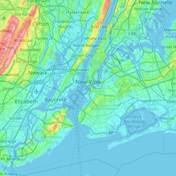
Name: New York topographic map, elevation, terrain.
Location: New York, United States (40.47658 -74.25884 40.91763 -73.70023)
Average elevation: 19 m
Minimum elevation: -6 m
Maximum elevation: 207 m
Other topographic maps
Click on a map to view its topography, its elevation and its terrain.
Sullvan Town Park
United States > New York > Madison County > Town of Sullivan > Village of Chittenango
Average elevation: 161 m